

The trails
Click here to open the trails map.
Download Trails Overview PDF
Busiest Visit Times: 9am-10am, 6pm-8pm 7 days a week
Visitor Counts
-
Central Meadows Trails Chambers Ck Cyn Trail
November 2021: 41,000 visitors 1,800 visitors
October 2021: 62,000 visitors 2,100 visitors
September 2021: 76,000 visitors 2,800 visitors
July 2021: 88,555 visitors 10,000 visitors
May 2021: 103,000 visitors 5,500 visitors
March 2021: 89,500 visitors 3,500 visitors
2020 Visitors: Totaled 559,000!
Trails reign supreme at Chambers Creek Regional Park! Do you want to be high above the world-class Chambers Bay Golf Course on the Grandview Trail to see osprey, seagulls, or eagles flying overhead or be closer to Puget Sound on the Soundview Trail where you can see harbor seals, sea otters, harbor porpoises, and the occasional orca or gray whale sighting? Do you prefer a hike along a stream in a wooded canyon? Luckily, you can do it all here on Pierce County’s Chambers Creek Properties located in University Place, Washington. Opt for a main trail described below, or select some of the many connected segments to create your own experience.
Grandview Trail
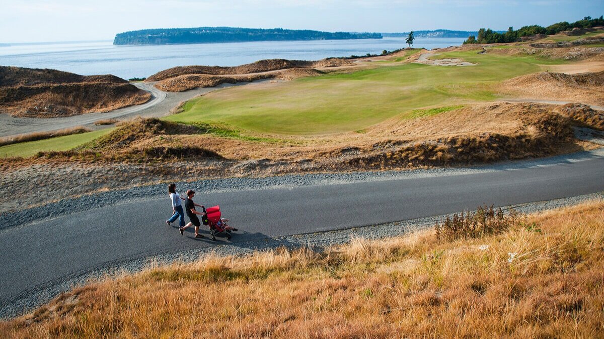
Located along the top of a 200-ft bluff with sweeping views of Chambers Bay Golf Course, Puget Sound, and the surrounding islands. It is connected at both ends to the Soundview Trail making the two trails a walkable loop.
Length: 1.25 miles (one way) from Curve Wall Plaza near the golf course entrance to the North Meadow Overlook (west of Playground by the Sound). Restroom at North Meadow.
Difficulty level: easy with a few moderate sections.
Access points: Numerous connections to sidewalks/street parking along Grandview Drive. Parking lots at North Meadow (4900 Block of Grandview Dr. W) Chambers Bay Golf Course (6320 Grandview Drive W) and Environmental Services Building (9850 64th St. W).
Users: walkers, runners, bike riders, skaters, wheelchair/disabled.
Soundview Trail (North)

Connects to the Grandview Trail at the golf course (near clubhouse) and at the North Meadow Overlook (top of switch-backs) making the two trails a walkable loop.
Length: 2 miles (one way).
Difficulty level: moderate to very difficult with grades in excess of 10% at north and south ends.
Access points: Parking lots at North Meadow (4900 Block of Grandview Dr. W) Chambers Bay Golf Course, and Central Meadow (6320 Grandview Drive W).
Users: walkers, runners, bike riders.
Central Meadow Trails
There are two connected segments Inner and Outer Loops.
Inner Loop goes from the Central Meadow parking lot through the center of the Meadow and loops around past the restrooms.
Length: 0.25 miles (one loop).
Difficulty level: easy.
Outer Loop goes around the 11-acre lawn and provides access to the Bridge to the Beach. Also connects to Soundview Trail.
Length: 0.67 miles (one loop). FYI: 3 loops equals two miles.
Difficulty level: easy to moderate.
Access points: Central Meadow parking lot (6320 Grandview Drive W).
Users: walkers, runners, bike riders, skaters, wheelchair/disabled.
Environmental Services Building (ESB) Trails

The main loop goes past the entrance to the ESB, then around/through the Playfields and Chambers Creek Labyrinth. Restrooms at the Playfields. Connects to 64th Street pathway, Curve Wall Plaza, Grandview, Soundview and East Slope trails.
Length: 0.5 miles (one loop).
Difficulty level: easy.
Access points: Environmental Services Building and Playfield parking lots (9850 64th St. W).
Users: walkers, runners, bike riders, skaters, wheelchair/disabled.
East Slope Trail
Accessed from Curve Wall Plaza and 64th Street pathway, just north of ESB. Descends/Ascends steeply throughout to the lower end Chambers Creek Road West.
Length: 0.5 miles (one way).
Difficulty level: very difficult with grades in excess of 13%.
Access points: parking lots at the ESB (9850 64th St. W) and Chambers Bay Golf Course upper lot (6320 Grandview Drive W). In the future there will be a bridge across Chambers Creek Road West to connect with the lower Canyon Trail and also a connection to the undeveloped South Meadow Trail system.
Users: walkers, runners, bike riders.
Chambers Creek Canyon Trail - Partial Closure

There are two unconnected segments at this time Lower and Upper Canyon Trails. Trail Closure: A section of the Chambers Creek Canyon Trail will be closed for bridge construction July 26 - November 2021. See Pierce County announcement.
Lower Canyon is a beautiful and wooded nature trail accessed at the 10400 block of Chambers Creek Road W. near the dam and fish ladder. While on the trails in the canyon keep an eye out for: deer, owls, and the occasional coyote sighting!
Length: 0.35 miles (one way). Near the top of the climb, there is a new trail segment that branches off from the main trail to the left. It will add approx. 1 mile and connect to Zircon Drive near the Oakbrook golf course in Lakewood.
Difficulty Level: moderate, but seems more difficult because it is unpaved/uneven.
Access Points: There is street shoulder parking near the dam and fish ladder, and along the roadway.
Users: walkers, runners.
Upper Canyon continues the woodland experience directly along Chambers Creek.
Length: 0.25 miles (one way). In the future, a series of bridges will connect this segment to the Lower Canyon Trail segments.
Difficulty level: moderate to difficult, depending on access point. Segment is unpaved/uneven.
Access points: There is street shoulder parking in the 6800 Block of Chambers Creek Road W. (access at this point is steep/difficult), and limited parking at the adjacent Kobayashi Park (6420 Chambers Creek Road W), with easier walking access.
Users: walkers, runners.